heavy rainfall

Montreal building more sponge parks, sidewalks to soak up heavy rainfall

Montreal building more sponge parks, sidewalks to soak up heavy rainfall

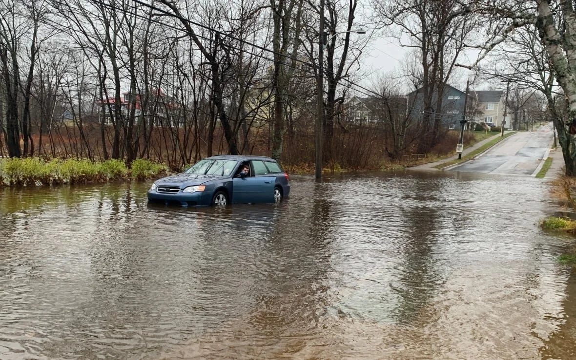
The city of Montreal is planning to build more urban "sponge" infrastructure to protect against future flood waters brought on by climate change. The announcement Tuesday came as Montreal once again found itself drying out after heavy rainfall pummelled the city in the early morning. The city plans to build 30 sponge parks and 400 more sponge sidewalks by 2025  — green spaces that naturally absorb excess rainfall instead of draining the water directly into neighbourhood sewers.

Boil water advisory issued for Alma

Boil water advisory issued for Alma

A boil water advisory has been issued for the village of Alma, about 79 kilometres south of Moncton, because of high levels of turbidity in the reservoir. "These levels exceed the New Brunswick maximum acceptable concentrations," a notice issued by the local government on Wednesday morning says. Recent heavy rainfall caused the problem, according to chief administrative officer Hanna Downey — a drastic change from last weekend when the village almost ran out of water and had to urge residents to conserve as much as possible.

'It's really bad': Town closes roads in Innisfil due to flooding

'It's really bad': Town closes roads in Innisfil due to flooding

“We dispatched staff from the Town of Innisfil to the impacted flood areas this morning to assist with diverting water away from homes and communicating with residents in the affected areas,” Nicole Bowman, director of operations said in an email. “Our crews are still on site diverting the water and we will continue to update residents through our website and social media channels.”

Edmonton weather: Heavy rainfall raises water level on North Saskatchewan River

Edmonton weather: Heavy rainfall raises water level on North Saskatchewan River

Welcome news as some areas in the province deal with flooding and high water levels. The City of Edmonton sent a public service announcement on Tuesday warning people to “exercise extreme caution around the North Saskatchewan River and its tributaries.” “Due to the continuous rain, the river, as well as shorelines and trails directly near the river, may be unsafe,” said the announcement. “Edmontonians may expect high water levels and increased current flow in the coming days. This may cause some flooding in areas running along the North Saskatchewan River and other natural waterways.”

EPA leader listens to water concerns in Mississippi capital

EPA leader listens to water concerns in Mississippi capital

EPA Administrator Michael Regan said Tuesday that the agency is still working on a plan to bring long-term improvements to the water system in Mississippi’s capital city, which came perilously close to collapsing more than two months ago. “I am here for the fourth time in one year because I want to hear directly from you,” Regan told dozens of business people, elected officials, pastors and others during a meeting at Jackson State University.

Southern Lakes sets high-water record

Southern Lakes sets high-water record

Water levels in the Southern Lakes region are the highest on record for Oct. 12. Heavy rainfall caused rising waters in Bennett Lake, Tagish Lake and Marsh Lake in late September and early October. The rising waters have prompted a high-water advisory, which means water levels could quickly rise but no major flooding is expected, for the region.

Brampton residents grappling with flood damage after area pelted with month's worth of rain

Brampton residents grappling with flood damage after area pelted with month's worth of rain

People in several Brampton neighbourhoods are grappling with swamped basements and other property damage Monday, one day after heavy rainfall caused localized flooding — and Environment Canada is warning the Greater Toronto Area could see more of the same Monday night. Prince Sharma was one of dozens of people who called the city about flood damage Sunday night. He told CBC News he was having dinner with his family when the storm hit. He said he heard running water so he went to inspect the basement of his Hardgate Crescent home, located near Wanless and Van Kirk drives.

Canadian refinery spills diesel into St. Clair River

Canadian refinery spills diesel into St. Clair River

An unknown amount of petrochemicals spilled into the St. Clair River from a refinery in Canada during heavy rainfall Wednesday night. An overflow in Suncor’s Sarnia refinery’s internal sewer system left a sheen on the river that caused officials on both sides of the international border to close off drinking water intakes. But Canadian authorities cleared water plants to return to normal activity Thursday morning.

Lake of the Woods water levels remain high as area deals with heavy rains this week

Lake of the Woods water levels remain high as area deals with heavy rains this week

Heavy rainfall in the Kenora area has slowed the drop in the Lake of the Woods water level. Municipalities in the Lake of the Woods watershed struggled with heavy flooding in recent months. The Lake of the Woods Secretariat, in its most recent update, stated the lake's level remains above its 2014 peak, but is below the record level set in July 1950. With recent rainfall in the area, and forecasted precipitation in the coming days, the lake is expected to rise slightly before resuming its drop, the secretariat said.

From drought relief to filling streams, heavy rain proves beneficial in Sask.

From drought relief to filling streams, heavy rain proves beneficial in Sask.

This week's heavy rainfall in Saskatchewan might have felt a bit excessive, especially for those in areas that were already drenched, but it has helped significantly in regions that needed the moisture. Some communities in the province are already above their average June rainfall amounts. According to Environment and Climate Change Canada data, North Battleford sits at about 110 millimetres so far this month. The city usually receives 65 mm in the entire month. About 101 mm fell in the span of a few hours on Tuesday.

B.C.'s North, Interior brace for flooding

B.C.'s North, Interior brace for flooding

Heavy rainfall on Friday and warmer temperatures through the week have parts of B.C.'s Interior and North preparing for the worst, as river levels and flood risk rise. Heavy rain is expected to continue through the weekend and temperatures are forecast to stay in the high teens. Hundreds of properties in B.C. are on evacuation alert, meaning residents should be prepared to leave at a moment's notice.

Some communities on floodwatch in Quebec's Saguenay region Social Sharing

Some communities on floodwatch in Quebec's Saguenay region Social Sharing

Authorities are keeping an eye on a number of rivers at risk of flooding in the Upper Saint-Maurice and Saguenay-Lac-Saint-Jean regions on Tuesday. One of these rivers, the Ashuapmushuan river, was already overflowing Tuesday morning. Girardville, a town on the north side of the lake, also experienced some minor flooding after a small creek spilled over onto some of its main streets.

Squamish braces for heavy rainfall and rising water

Squamish braces for heavy rainfall and rising water

Warmer temperatures and heavy rainfall are expected for Squamish, prompting the municipality to brace itself for another series of rising water events. Environment Canada has issued a rainfall warning for Howe Sound. Rainfall of between 75 to 100 mm is expected between Tuesday and Wednesday afternoon. "Rising freezing levels with melting snow giving rise to high stream flows and localized flooding," the alert reads.

The Sprout: Recovering from floods will take years: B.C. farmers

The Sprout: Recovering from floods will take years: B.C. farmers

We start in British Columbia, where more heavy rainfall is expected this week and flooding shows no signs of abating. Floodwaters in the hard-hit community of Abbotsford are rising again as the Nooksack River south of the border overflows. Farmers in the region continue to assess the damage to their operations. As the Canadian Press reports, blueberry farmer David Gill says the devastating floods have set famers back by “at least a decade” and it will take them years to recover. Thousands of livestock were killed in the floods and fields across the Fraser Valley are still flooded with contaminated water. As CBC News reports, experts say it will be weeks before farmers know how the contaminated waters have affected the region’s fertile farmland.

'There's nothing to stop it': Floodwaters rising in Abbotsford as Nooksack River overflows

'There's nothing to stop it': Floodwaters rising in Abbotsford as Nooksack River overflows

Abbotsford Mayor Henry Braun says he's increasingly concerned about rising waters in and around his city as a series of atmospheric rivers continues to pummel B.C.'s South Coast. During a news conference on Sunday, Braun said Whatcom County in Washington state had advised that water has now risen above a dike on the Nooksack River, and it's pooling between the river and a nearby road.

Could take 'days or weeks' to fix flood-damaged parts of Cape Breton

Could take 'days or weeks' to fix flood-damaged parts of Cape Breton

It could be "days or weeks" before things get back to normal in flood-ravaged parts of Cape Breton following the rain and wind storm that swept across Nova Scotia, according to a provincial transportation official. Jamie Chisholm, the Department of Transportation's eastern district director, said Wednesday the hardest hit areas were Inverness and Victoria counties. "We've had multiple bridges compromised, some washed out completely, several roads that are impassable right now," he said.

Province warns next 10 days could be 'quite challenging' as more storms set to hit B.C.

Province warns next 10 days could be 'quite challenging' as more storms set to hit B.C.

British Columbia is bracing for more rainfall in the coming days and weeks as the province works to rebuild after unprecedented precipitation earlier this month. Up to 80 millimetres of rain is forecast for Metro Vancouver, Howe Sound, Whistler and the Fraser Valley, starting this morning and continuing until Friday. Strong southeast winds near the water are also predicted as part of this weather system, and freezing levels will rise above mountain tops, which could trigger snowmelt and worsen the flooding situation.

Could take 'days or weeks' to fix flood-damaged parts of Cape Breton

Could take 'days or weeks' to fix flood-damaged parts of Cape Breton

"A lot of it, we're going to find, I guess, more damage as the water recedes, because it's really hard to tell until the water recedes," he said. "It's probably easier to describe the number of roads that don't have problems than the ones that do." The Emergency Management Office is asking people in Inverness and Victoria counties to stay off the roads. Lyle Donovan, EMO co-ordinator in Victoria County, said more than a dozen roads are washed out and a man was injured when his car got stuck on one of the damaged roads.

City of Campbellton doesn't know when boil water advisory may be lifted

City of Campbellton doesn't know when boil water advisory may be lifted

After more than a month of dealing with a boil water advisory, Campbellton Mayor Ian Comeau says the city still has no idea when it could be lifted. The advisory has been in place since Sept. 24 because of high turbidity in the drinking water, meaning the water is too cloudy to safely drink. Residents have been told to keep water at a rolling boil for at least one minute if it's being used for drinking, cooking, or brushing teeth. The city also advised residents to sponge wash young children to ensure they don't ingest the water.

Pooling water prompts warnings for Island highways

Pooling water prompts warnings for Island highways

Travel advisories are in effect for pooling water on several Vancouver Island Highways. Drive B.C. issued warnings Saturday morning that heavy rainfall had caused water buildup in several locations: Trans-Canada Highway north of Duncan, between Herd Road and Mount Sticker Road. Highway 4, between Wick Road and the Taylor River rest area. Highway 19, from Cook Creek Road south of Cumberland to Sayward Road north of Campbell River. There are also high winds in the area.