high water levels

Edmonton weather: Heavy rainfall raises water level on North Saskatchewan River

Edmonton weather: Heavy rainfall raises water level on North Saskatchewan River

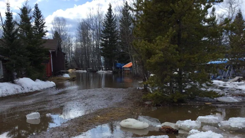
Welcome news as some areas in the province deal with flooding and high water levels. The City of Edmonton sent a public service announcement on Tuesday warning people to “exercise extreme caution around the North Saskatchewan River and its tributaries.” “Due to the continuous rain, the river, as well as shorelines and trails directly near the river, may be unsafe,” said the announcement. “Edmontonians may expect high water levels and increased current flow in the coming days. This may cause some flooding in areas running along the North Saskatchewan River and other natural waterways.”

'Here we are again': Flood warning returns for Klondike River, evacuation underway

'Here we are again': Flood warning returns for Klondike River, evacuation underway

A tactical evacuation is underway once again in the Rock Creek area near Dawson City, Yukon, as the Klondike River continues to run dangerously high. Officials have issued another flood warning for the area, a little more than a week after an earlier warning was downgraded to a flood watch. A tactical evacuation means that residents are advised to leave the area, but are not under an evacuation order.

Thunderstorm watch ends for London as high water levels remain in Thames River watershed

Thunderstorm watch ends for London as high water levels remain in Thames River watershed

A severe thunderstorm watch has ended for London, Ont. and Middlesex County area, however rain showers and a risk of thunderstorm remains in the forecast for Wednesday evening. A severe thunderstorm watch remained in place as of 4 p.m. for Elgin County, while watches in Huron-Perth, Oxford County, and Sarnia-Lambton had ended. Rainfall warnings remained in place for southern Huron and southern Perth counties, calling for rainfall amounts of between 30 and 50 millimetres.

Southern Lakes sets high-water record

Southern Lakes sets high-water record

Water levels in the Southern Lakes region are the highest on record for Oct. 12. Heavy rainfall caused rising waters in Bennett Lake, Tagish Lake and Marsh Lake in late September and early October. The rising waters have prompted a high-water advisory, which means water levels could quickly rise but no major flooding is expected, for the region.

Floods, droughts, storms will cost Canadian economy $139B in next 30 years, report says

Floods, droughts, storms will cost Canadian economy $139B in next 30 years, report says

Floods, droughts and major storms that wash out highways, damage buildings and affect power grids could cost Canada's economy $139 billion over the next 30 years, a new climate-based analysis predicts. The report, titled Aquanomics, was published Monday by GHD, a global engineering and architecture services firm. In an interview with CBC News, the firm's Canadian water lead Don Holland said that the value of water and the costs associated with it are underacknowledged.

High water levels on Lake Winnipeg play havoc with businesses, tourism

High water levels on Lake Winnipeg play havoc with businesses, tourism

Sandy Roman calls her work "the best job in the whole world," but lately, she's been facing a world of frustration. Roman owns Sandy's Chipstand, a snack shack in Patricia Beach Provincial Park, along the east side of Lake Winnipeg, which is seeing its worst flooding since Manitoba Hydro started regulating levels in 1976. "It's a little difficult. It's a little difficult for sure. You just don't know when you wake up in the morning, am I going to work today? Are people are going to get fries?" she told CBC Information Radio host Marcy Markusa on Friday.

Lake of the Woods water levels remain high as area deals with heavy rains this week

Lake of the Woods water levels remain high as area deals with heavy rains this week

Heavy rainfall in the Kenora area has slowed the drop in the Lake of the Woods water level. Municipalities in the Lake of the Woods watershed struggled with heavy flooding in recent months. The Lake of the Woods Secretariat, in its most recent update, stated the lake's level remains above its 2014 peak, but is below the record level set in July 1950. With recent rainfall in the area, and forecasted precipitation in the coming days, the lake is expected to rise slightly before resuming its drop, the secretariat said.

Strong winds, high water levels lead to flooding along western shores of Lake Winnipeg

Strong winds, high water levels lead to flooding along western shores of Lake Winnipeg

People living in and around Gimli, Man. are cleaning up after high lake levels and heavy winds caused flooding along the western shores of Lake Winnipeg. The situation sent waves crashing onto lakefront properties and swamped some popular destinations over the weekend, prompting calls for a better warning system to respond to similar situations in the future.

High water levels cause partial closure along Trent-Severn Waterway

High water levels cause partial closure along Trent-Severn Waterway

A portion of the Trent-Severn Waterway will be closed starting Friday due to high water levels and flows. Lock 19 - Scotts Mills and Locks 22 through 27, including Lakefield, will be closed until further notice. Parks Canada says the Trent Severn's watersheds have received "significant amounts of precipitation, the equivalent of 100 to 200 per cent above the normal amount." It advises residents and visitors to use "extreme caution" around and on the water.

For Ontario's most northern riding, there's a feeling of neglect that residents are looking to change

For Ontario's most northern riding, there's a feeling of neglect that residents are looking to change

In one of Ontario's newest electoral ridings, residents hope whichever party forms the next provincial government will fix a longstanding sense of neglect and address a wide range of issues disproportionately felt in the far north. Kiiwetinoong — which means north in Ojibway — is the largest riding in Ontario by geographic area, but one of the smallest in terms of population. It was one of two new ridings created for the 2018 election, and the majority of the population is Indigenous.

Sambaa K'e, N.W.T., drying out after flash flood Sunday

Sambaa K'e, N.W.T., drying out after flash flood Sunday

Water levels have receded in Sambaa K'e, N.W.T., after a flash flood Sunday swamped some homes and properties. Dennis Deneron said there are still some low-laying areas with high water levels in the community of about 90 residents, but the community can begin cleanup now. The flood happened when ice blocked the main channel of Island River, which flows into Trout Lake. Deneron said that forced the water through another channel close to the community and into some people's yards.

Restoration work at Hillman Marsh to protect region from erosion, maintain wildlife

Restoration work at Hillman Marsh to protect region from erosion, maintain wildlife

Two years after erosion at Hillman Marsh Conservation Area was considered "gravely concerning," the coastal wetland in Ontario is now undergoing restoration work to better protect it. In 2019, the Essex Region Conservation Authority (ERCA) told CBC News that erosion along the coastline — specifically along Wheatley Provincial Park, Hillman Marsh and Point Pelee National Park — was "active and significant."

Just over 20% of Yukon's health facilities at risk to future flooding, report warns

Just over 20% of Yukon's health facilities at risk to future flooding, report warns

Flooding has been an immediate and pressing concern for Yukoners so far this summer, with some people now finding themselves under an evacuation alert as water levels near their homes creep up. But a report out last month from Canadian Institute for Climate Choices (CICC) suggests that when it comes to floods, the territory needs to start looking decades into the future as well. Researchers at the institute looked at how many health centres in Canada are built in areas that put them under threat of being affected by floods occurring 20, 50 and 100 years from now.

How high could water levels get in southern Yukon? It now depends a lot on rain

How high could water levels get in southern Yukon? It now depends a lot on rain

Yukoners wondering just how high water levels could get this summer should start looking to the skies. Though flood warnings remain in place for the Southern Lakes, Lake Laberge, and the Yukon River at Carmacks, Kat Hallett, a spokesperson for the government of Yukon, said one source of rising water appears to be running out. "What we've noted over the last few days is that rates of rise are decreasing a little bit," she told host Elyn Jones on CBC Radio's Yukon Morning on Tuesday.

Spring flooding still a concern with Great Lakes water levels

Spring flooding still a concern with Great Lakes water levels

The Great Lakes has had a history of high water levels in the spring, posing a significant threat for flooding and shoreline erosion. So, will they be a problem again this spring? In the last 12 months, precipitation has been anywhere between 10-20 per cent below average. However, a lack of precipitation doesn't mean that the lake levels are going to drop in a "big way" immediately, says Weather Network meteorologist and Storm Hunter Mark Robinson.