These green crabs aren't just a West Coast problem. Fisheries and Oceans Canada notes that the species, which originally came from Europe and North Africa and likely hitched a ride to North America on wooden ships in the early 19th century, first invaded east coast waters in the 1950s.
First Nation calls on B.C. to restore shellfish harvesting sites closed for decades due to poor water quality
A First Nation on Vancouver Island has been legally barred from accessing one of its primary traditional food sources for the past 25 years, one of 154 shellfish harvesting sites closed by federal law in B.C. due to poor water quality. Some of those sites may be safe at times, a recent audit concluded, but they cannot be reopened because the federal agency in charge of testing those waters is understaffed. As a result, it devotes the majority of its limited resources to commercial harvesting areas. Shellfish beds First Nations have relied on for as long as their people have existed haven’t been given such high priority.
B.C. warns of summer drought and asks people to conserve water
The British Columbia government is urging people to save water, saying the forecast predicts drought across much of the province this summer. A statement from the Forests Ministry says recent rains have provided some relief in parts of B.C., but it hasn't been enough to make up the deficit. B.C.'s drought map shows much of the northeastern corner of the province is at drought level four on the five-level scale, meaning conditions are extremely dry, with communities and ecosystems likely to experience adverse impacts.
First Nation on Vancouver Island declares marine protected area
The Tsawout First Nation, located 20 kilometres north of Victoria, B.C., has declared an Indigenous Protected and Conserved Area (IPCA) for 155 kilometres of ocean in its traditional waters. The area will be called QEN'T Marine Protected Area. QEN'T — pronounced "qwant" — means "to be looking after," "caring for," or "protecting something or someone" in SENĆOŦEN.
Bright orange ocean water being tested by B.C. scientists
Scientists are taking a close look at a bright orange algae bloom found in the ocean off Vancouver Island and the Sunshine Coast. Svetlana Esenkulova, a biologist with Pacific Salmon Foundation, is trying to determine if the phytoplankton bloom is negatively impacting salmon. “Noctiluca blooms can disrupt the overall balance of marine ecosystems as they ‘steal’ food from zooplankton,” she said. Under a microscope, the organisms "look like giant watermelons with pigtails and they wave those pigtails," said Esenkulova, who has a sample of the orange ocean water in her kitchen. When the water is cold, she can see the organisms trying to catch food.
Beavers could help replace artificial dams being decommissioned on Vancouver Island
Members of a Canadian conservation organization are working on a project to increase biodiversity and healthy wetlands in British Columbia with the help of beavers. Ducks Unlimited Canada is mapping areas in the province where beavers can replace artificial dams once they've been decommissioned. "Beavers are a keystone species," said Jen Rogers, a master's student at Simon Fraser University working with Ducks Unlimited Canada. "They're considered ecosystem engineers."
Heavy rain sets off high-water warnings for rivers in southern B.C.
High streamflow advisories have been issued for two more regions as heavy rain sweeps over British Columbia’s southern Interior. B.C.’s River Forecast Centre added the advisories for the Similkameen and Okanagan regions after previously issuing bulletins for all of Vancouver Island, the Sunshine Coast and Metro Vancouver through to the Fraser Valley.
More than a third of Richmond's drinking water pipes have asbestos
More than a third of the City of Richmond’s pipes delivering drinking water to its residents are made of cement containing asbestos. The statistic came to light last week on CTV’s W5 investigation show, with Richmond having the ninth-highest percentage of asbestos cement pipes - compared to its entire network - among the 100 cities contacted nationwide.
B.C’s pink sea urchins are on the move to shallower waters thanks to climate change
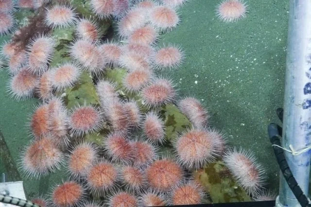
Pink sea urchins off the coast of Vancouver Island are expanding into shallower waters, in what researchers say is an indication of how rapidly climate change is affecting ocean life. Researchers at Memorial University, Ocean Networks Canada and the University of Victoria found the urchins, living as deep as 400 metres below, were expanding their populations into shallower water at an average rate of 3.5 metres per year as ocean warming reduces oxygen levels and food sources at lower depths.
Cargo from 2021 Zim Kingston spill still washing up on Island shores
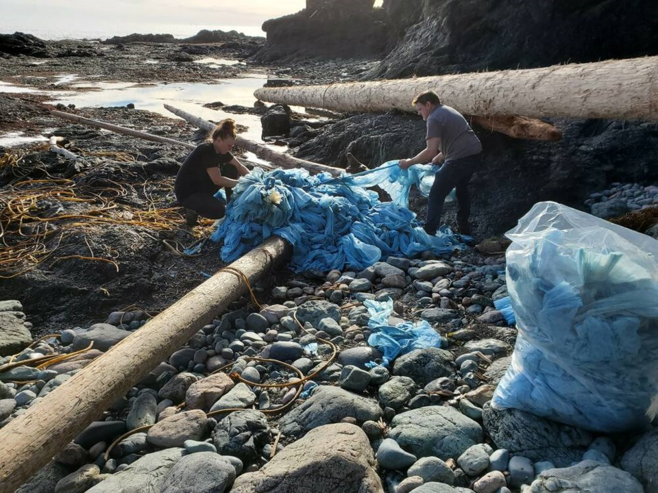
When Jill Laviolette started picking debris off Cape Palmerston beach on Vancouver Island following the container spill from the MV Zim Kingston freighter, the inflatable dinosaur and unicorn toys she pulled from the sand looked nearly pristine. More than a year later, consumer goods from some of the ship’s 109 lost containers still wash up on British Columbia shores, the inflatable toys now torn to pieces by the elements to be picked up alongside vacuum cleaner parts, bike helmets, coolers and urinal mats.
Historically high tide causes flooding risks in parts of B.C.
The peak of a so-called king tide has passed without major damage in Vancouver, as flood watches and high streamflow advisories remain posted across Vancouver Island and much of B.C.'s inner south coast. The big tide combined with heavy rain and snowmelt had raised the risk of flooding after pre-Christmas snowstorms. Environment Canada said the tide pushed water levels at Point Atkinson in West Vancouver to a height of 5.70 metres, breaking the previous record of 5.61 metres set in 1982.
Severe water shortage at B.C. ski resort forces staff to ask visitors to bring their own
Drought conditions on Vancouver Island are now impacting winter activities at a popular ski destination. Mount Washington Alpine Resort, located about a 30-minute drive from the Comox Valley, is set to open Friday, Dec. 9, and a lack of snow on the hill and water in the local reservoirs mean visitors will have limited terrain to play on and will have to bring their own drinking water.
From urinal mats to unicorns, cargo from major container spill is still washing up on B.C. shores
When the Zim Kingston spill happened, much of the early public attention was focused on two missing containers that carried the hazardous chemicals potassium amyl xanthate and thiourea dioxide. Those containers have not been located. Both Hoyland and Laviolette say the amount of plastic that went into the water can be hazardous in its own way, polluting the environment and the food chain or injuring animals before eventually making landfall.
What is blue carbon and why is it vital for mitigating Canada's carbon emissions?
Marlow Pellatt spent time on Vancouver Island, taking samples of soil from deep underground and wading through water to understand the biodiversity in the area. To an onlooker, it may seem like he’s playing in mud, but he’s actually researching how important coastal ecosystems are in Canada’s fight against climate change. Pellatt, a coastal ecologist with Parks Canada, led a team that was part of an international effort to study and preserve coastal systems this year. The joint initiative involves Canada, the U.S. and Mexico to study "blue carbon" -- the carbon stored in marine ecosystems.
Next atmospheric river on its way to B.C., bringing heavy rain and hope to drought-stricken areas
The next atmospheric river of the season is forecast to bring heavy rain to coastal British Columbia by late Thursday and this one could drench drought-stricken areas that have been bypassed by recent storms. Rain is predicted to be heaviest on the west coast of Vancouver Island, where about 80 millimetres could fall in less than 36 hours, while Environment Canada models show some Metro Vancouver communities could receive 60 millimetres or more.
Low creek levels on Vancouver Island threaten spawning salmon
It’s the time of year when salmon are returning to freshwater to spawn, but across the Island, fish are holding out in the ocean, waiting for the seasonal rise in creek levels to take hold and allow them to complete their life cycle. On average, Victoria sees about 88 millimetres of rain in October; so far there has been none with no precipitation in the forecast for the next week. In fact, it’s been weeks since the Island had any sizable amount of rain at all. Greater Victoria alone has only had 2mm since July 8, and water levels are falling across the region.
Some B.C. regions at Drought Level 4 as water scarcity affects the province
Little to no rainfall over the past five weeks in several areas of British Columbia has prompted a warning from the Ministry of Forests about drought. The ministry says Vancouver Island, the inner south coast and the northeast corner of the provincehave reached the second-most severe level of drought on a five-point rating scale. A statement from the ministry says those regions are ranked at Drought Level 4, meaning conditions are extremely dry and will likely have unfavourable impacts on everything from jobs to ecosystems.
Plan to create vast B.C. network of protected ocean opens to public
A plan to create a vast network of marine protected areas stretching from Vancouver Island to the Alaskan border inched closer to reality this Monday after the governments of Canada, British Columbia and over a dozen First Nations released a draft plan to the public. If enacted, the marine protected areas (MPAs) would protect nearly a third of the Northern Shelf Bioregion — a 100,000-square-kilometre tract of ocean also known as the Great Bear Sea.
B.C. warns of rising drought levels on Vancouver Island
Persistent dry and hot conditions on British Columbia's coast led the provincial government to raise all of Vancouver Island as well as the Haida Gwaii basin to drought level 3 on Saturday. People who live in eastern and western Vancouver Island and Haida Gwaii are being asked to reduce their water consumption wherever possible and to respect watering restrictions issued by local and regional governments, water utility providers or irrigation districts. "The high temperatures, consistent sunshine and lack of recent rain have increased water temperatures in numerous Vancouver Island and Haida Gwaii streams," B.C.'s Ministry of Forests said in a news release.
'Whole change of life': Vancouver Island First Nation gets drinkable tap water, some still without
Members of the Cowichan Tribes First Nation on Vancouver Island are relieved to finally have drinkable water coming from their taps, though some members are still going without. Clean water is a necessity that many in Canada take for granted, but for 20 households on Indian Road in the First Nation on southern Vancouver Island, it's only recently become accessible.


