flood risk

State of emergency declared in Quebec town due to flood risk, more towns evacuating

State of emergency declared in Quebec town due to flood risk, more towns evacuating

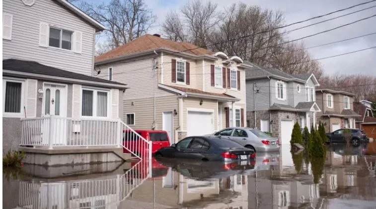
A town near Quebec City declared a state of local emergency and other communities ordered preventive evacuations on Tuesday as torrential rain caused rivers across southern Quebec to burst free of their banks. By Tuesday, between 500 and 600 people were forced from their homes in Ste-Brigitte-de-Laval, where the mayor declared a state of emergency for the next 48 hours.

1 home destroyed as flood risk prompts more evacuation orders in Cache Creek, B.C.: fire chief

1 home destroyed as flood risk prompts more evacuation orders in Cache Creek, B.C.: fire chief

Flooding in B.C.'s Interior has destroyed one home and forced several others to be evacuated, according to the local fire chief.  Evacuation orders are now in place for five properties — including the local firehall — in the Village of Cache Creek, B.C., where a local state of emergency was declared on May 1 as the nearby creek and river threatened homes in the area and posed an "imminent threat to people and property."

Evacuation order issued in northern Okanagan as Whiteman's Creek overflows

Evacuation order issued in northern Okanagan as Whiteman's Creek overflows

Residents of several properties in B.C.'s North Okanagan were ordered to evacuate their homes as a nearby creek overflowed Tuesday. Officials say they're concerned about the flood risk associated with Whiteman's Creek, close to where it empties into Okanagan Lake about 70 kilometres north of Kelowna, B.C. According to the Okanagan Indian Band, which issued the evacuation order, residents on the south side of Falcon Avenue, adjacent to Whiteman's Creek, must leave their properties immediately. This includes people living at addresses 161 to 195 Falcon Avenue, as well as Nos. 54 and 55. 

High risk of flooding around Dawson City, Yukon, as late spring thaw arrives

High risk of flooding around Dawson City, Yukon, as late spring thaw arrives

The latest ice breakup forecast for Yukon suggests there may be some flooding in the Dawson City area this spring, though not likely in town. "We assess the flood risk as low for Dawson City proper, the town itself, because it is protected by the dike," said Anthony Bier, the Yukon government's acting senior hydrologist. It's been a cool spring so far in the Dawson area, and a lot of snow fell over the winter. The amount of snow on the ground — called the snowpack — is higher than it usually is, meaning more water hitting the rivers once things start melting.

Swift Current continues state of emergency due to flood risk from creek levels

Swift Current continues state of emergency due to flood risk from creek levels

Swift Current will remain in a state of emergency, as rising waters encroach on the edges of the Swift Current Creek, officials said Saturday. The city declared the emergency as a proactive measure on Tuesday evening, in response to rising creek levels. The declaration allows the southwestern Saskatchewan city to restrict access to areas that are under flood conditions and to work zones.

Red River expected to spill its banks in Manitoba this spring as flood outlook worsens

Red River expected to spill its banks in Manitoba this spring as flood outlook worsens

The Red River is now expected to spill its banks in several places in Manitoba this spring, but is not projected to rise high enough to threaten any communities protected by ring dikes. Provincial flood forecasters raised the flood risk for the Red River from moderate to major on Wednesday, thanks to major snowstorms in recent weeks south of the border.

Catastrophe experts say retreat from flood risk is 'critical option'

Catastrophe experts say retreat from flood risk is 'critical option'

All climate disasters are not created equal and the Institute for Catastrophic Loss Reduction recommends retreat in the face of only one type of threat. "In our opinion, retreat is not an option that is important for most climate hazards in Canada. The hazard where retreat is really important and quite viable and a critical option involves flooding," executive director Paul Kovacs said.

Fighting Floods, or Living with Water?

Fighting Floods, or Living with Water?

Every year, Lower Mainland residents prepare for the Big One. The region is located near the Cascadia subduction zone, and it’s only a matter of time before a megathrust earthquake hits. During the annual Oct. 20 ShakeOut event in southwest B.C., school kids practice diving under desks. People ready their workplaces with emergency kits and evacuation plans. But there’s another type of disaster that we’re reminded about less often: a major flood.

B.C.'s North, Interior brace for flooding

B.C.'s North, Interior brace for flooding

Heavy rainfall on Friday and warmer temperatures through the week have parts of B.C.'s Interior and North preparing for the worst, as river levels and flood risk rise. Heavy rain is expected to continue through the weekend and temperatures are forecast to stay in the high teens. Hundreds of properties in B.C. are on evacuation alert, meaning residents should be prepared to leave at a moment's notice.

Water recedes, flood risk subsides in Kashechewan First Nation

Water recedes, flood risk subsides in Kashechewan First Nation

The water has receded near Kashechewan First Nation, which has reduced the risk to the community. Discussions are now underway to return people home. The northern Ontario community experienced its annual spring flooding from the nearby Albany River. Hundreds of residents were flown to host communities: Kapuskasing, Thunder Bay and Val Rita-Harty. The risk to the community has subsided said Wilbert Wesley, emergency management services manager for Mushkegowuk Council. He is also the custodian helping the First Nation during its evacuation phase.

Some Jean Marie River residents are moved into new homes but worry about flood risk

Some Jean Marie River residents are moved into new homes but worry about flood risk

Last spring, when Lucy Simon walked into her family home and business after the flood waters in Jean Marie River First Nation receded, she started to cry. "We lost everything," she told CBC News on Friday. "The most important thing to me that I lost dearly is that the water went over my parents grave and my kids' baby pictures." She also lost freezers full of meat. Simon ran Lucy's Bed and Breakfast, a place where she provided traditional foods to guests. But she will not be continuing the business when the home is repaired. She's currently living in a trailer that she said is nice, but a small space for all her art supplies that her husband will occasionally trip over.

Fort Simpson waits anxiously for spring melt as N.W.T. gov't warns of flood risk

Fort Simpson waits anxiously for spring melt as N.W.T. gov't warns of flood risk

The mayor of Fort Simpson, N.W.T. said he is feeling trepidation as May approaches, after the community dealt with devastating flooding that time last year. Sean Whelly said the combination of snowfall and water levels, plus a late spring is raising anxieties in the town. "We've been warned by the territorial government that we're at high risk to experience some flooding again this year, so we're concerned," he said.

Flood warnings for Lower Mainland and Vancouver Island with heavy rain, rising temperatures in forecast

Flood warnings for Lower Mainland and Vancouver Island with heavy rain, rising temperatures in forecast

The agency that monitors British Columbia's waterways is warning of "minor to significant flooding" in B.C.'s Lower Mainland and Vancouver Island as warming temperatures and persistent rain melt heavy snow. The River Forecast Centre says in a high stream-flow advisory that a significant weather pattern change will occur this week and cause rapid rises in creeks and rivers, especially at low and mid-elevation watersheds on the coast.

'It's overwhelming': Yukoners struggle to save homes from flood water

'It's overwhelming': Yukoners struggle to save homes from flood water

Yukoner Florian Lemphers has been watching the water creep ever closer to his home over the last two weeks. A five-foot tall fence on the outer edge of his Shallow Bay property is now peeking just a few inches above the waterline. "It's very, very sad. We've been here for 38 years and we've never seen anything like this," he said on Monday. "It has been a labour of love over the last 38 years, putting this place together, and it's very, very hard to see it be threatened this way. So we're doing the best we can."

Tree planting can reduce flood risk, say wildlife and watershed groups

Tree planting can reduce flood risk, say wildlife and watershed groups

Simon Mitchell of the World Wildlife Fund and Natalie Deseta of the Nashwaak Watershed Association say planting trees, shrubs and grasses along the river and its tributaries can help reduce the risk of bad flooding in spring and from extreme rain events. "When we're thinking about flooding," said Mitchell, "our biggest issue is the frequency and intensity at which these events come." Mitchell is a habitat specialist who studies the St. John River and a vice president with the Canadian WWF based in the Nackawic area.

'It's a problem for society': Climate change is making some homes uninsurable

'It's a problem for society': Climate change is making some homes uninsurable

As an insurer, Intact obviously has its own data and maps. Based on that, the company assumes as many as five per cent of those newly at-risk properties will be simply uninsurable. Brindamour warns that "if you're in a zone that gets flooded repeatedly, or where the odds of being flooded has increased meaningfully, it'll be hard to find insurance from private capital."