rainfall

Less snowpack, low rainfall, higher demand. Experts offer answers on low water levels in Lethbridge

Less snowpack, low rainfall, higher demand. Experts offer answers on low water levels in Lethbridge

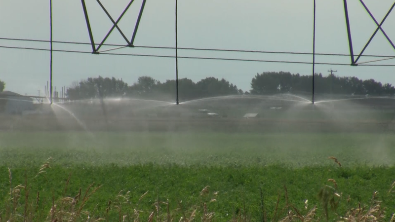
Water levels in the Oldman River reservoir are the lowest they've ever been since its construction in the early 1990s. The reservoir and the river are responsible for supplying water to a number of local communities, including Lethbridge. The City of Lethbridge said in a release that while there's no immediate danger of being left without an adequate supply of drinkable water in the city, the lower-than-average water levels across southern Alberta is something they are watching closely.

Receding water levels a concern for Gull Lake, Alta.

Receding water levels a concern for Gull Lake, Alta.

Residents of Gull Lake, Alta., are concerned about drastically receding water levels and are trying to come up with creative solutions to refill the popular lake. Keith Nesbitt has lived in Gull Lake since 2007 but has been coming to the lake recreationally since the ’80s. As a director with the lake’s watershed society, he’s concerned about how much the water levels have dropped this year. “You can look at the beach here and you can see what’s happened to it. The boats are out even further. It’s getting critical, we have to do something with the lake,” he said.

Hudson Valley Flood Emergency Triggers Rescues; Woman Drowns In Orange County, New York

Hudson Valley Flood Emergency Triggers Rescues; Woman Drowns In Orange County, New York

A​n estimated half-foot of rainfall or more inundated areas of New York's Lower Hudson Valley region on Sunday, washing out roads and overwhelming vehicles to the point that drivers needed to be rescued. O​ne death has been blamed on the flooding. In Orange County, New York, a woman drowned while trying to evacuate her home, according to the Associated Press. "​Her house was completely surrounded by water," Orange County Executive Steven Neuhaus told the AP. He added: "She was trying to get through (the flooding) with her dog, and she was overwhelmed by tidal-wave type waves."

Water use restriction issued for County of Newell

Water use restriction issued for County of Newell

Low water flow in the Bow River has forced the Eastern Irrigation District (EID) to issue a water use restriction for the County of Newell. The EID says they have seen a dramatic drop in average river flow levels in both the Bow River and Highwood River this year. In a typical year flow in the Bow River starts to drop off by the middle and end of July. This year the EID says the Bow River dropped by the beginning of June.

Hot and dry summer could affect Calgary's water levels

Hot and dry summer could affect Calgary's water levels

The beginning of June in Calgary has been hot and dry, and that could have an affect on the city’s water supply through summer. Environment Canada and Climate Change Canada (ECCC) says Calgary has come into the summer season with dryer than normal conditions — spring 2023 ended as the fifth driest spring on record.

'Exercise extreme caution': Heavy rainfall causes rising water on North Saskatchewan River

'Exercise extreme caution': Heavy rainfall causes rising water on North Saskatchewan River

Edmontonians are being asked to “exercise extreme caution” as water levels rise on the North Saskatchewan River and its tributaries following continuous rainfall this week. City officials in a Thursday news release warned that the river, shorelines and trails directly near the river may be unsafe due to rising water levels and increased current flow following a rain storm that dumped a large amount of rain on the province over the last 24 hours. The city said flooding may occur in some areas along the North Saskatchewan River and other natural waterways.

Waterloo Region’s water conservation bylaw in effect

Waterloo Region’s water conservation bylaw in effect

Using water from a rain barrel, watering can or other non-municipal sources does not fall under this restriction. The water conservation bylaw is in effect every year from May 31 to Sept. 30. Before it was enacted, water use spiked by 50 per cent during the summer months, putting a strain on the region’s water supply.

Goulais River water levels begin to fall: Hydrometric data

Goulais River water levels begin to fall: Hydrometric data

Residents in Goulais have taken to social media to share photos of this week’s significant flooding that has taken place in the area. Warmer weekend temperatures and some rainfall to start the work week has melted much of the remaining snow, leaving some roadways in the Goulais area inaccessible. According to the Government of Canada’s hydrometric data research, the latest water level measurements taken from Goulais River near Kirby’s Corner appear to have peaked today and those numbers are slowly beginning to fall.

Water restrictions for Metro Vancouver on the way, regional district says

Water restrictions for Metro Vancouver on the way, regional district says

Metro Vancouver is warning its residents and businesses that water usage for lawns will be restricted beginning next month. Starting May 1, seasonal regulations that limit lawn watering to once per week will come into effect in an effort to conserve the region’s drinking water for the coming hot and dry months. “We are increasingly seeing variable weather patterns due to climate change, and we can’t always count on rainfall to replenish our water supply when we need it,” said George V. Harvie, Metro Vancouver board of directors chair.

What are El Niño and La Niña, and how do they change the weather?

What are El Niño and La Niña, and how do they change the weather?

Winds blowing along the Equator above the Pacific Ocean - from South America in the east towards Asia in the west - were stronger than normal. These "trade winds" piled warm water off the coast of Asia, raising the sea surface level. In the east, near the Americas, cold water flowed upwards to the surface. During El Niño the opposite happens - weaker trade winds mean the warm water spreads out back towards the Americas, and less cold water rises towards the surface.

Why California's storm is unlikely to reverse its drought

Why California's storm is unlikely to reverse its drought

California - one of the driest states in the US - is being inundated with torrential rain and flooding. And given the decades-long drought in the region, which has led to restrictions on water usage in some areas, you might be wondering if this extreme weather could in some ways be a positive. But the downpour is unlikely to have a big impact on the drought. In fact, experts say it would take consecutive years of severe wet weather to reverse it in the long-term.

Mid-Island beaches feeling effects of king tide

Mid-Island beaches feeling effects of king tide

“We had a storm surge as well, which added to that. The storm surge is separate from king tides, it’s a rise in water that happens generated by storms, and this one was generated by a storm off the coast. Those two factors together gave us some pretty high water levels on the 27 (of Dec.). “ Charbonneau said the tides are expected to diminish over the next few days, and shouldn’t be as high as what was seen on Tuesday. Southeastern winds and storm surges are also factors in increasing the size of waves.

UBCO engineers dive into local flood recovery, prevention

UBCO engineers dive into local flood recovery, prevention

While infrastructure clean-up and repairs continue across the province after the extreme weather events of 2021, UBC Okanagan researchers have created measures to help municipalities mitigate damage from future climate-related disasters. “Communities across British Columbia have established strong policies and strategies to prepare and limit damage due to these extreme events, but policies related to post-disaster management are still in their infancy,” says Sadia Ishaq, a doctoral candidate in UBCO’s School of Engineering and lead author of a new paper that examines municipal risk management strategies.

One year after flooding disaster, recovery continues for Fraser Valley farmers

One year after flooding disaster, recovery continues for Fraser Valley farmers

Farmer Richard Bosma points to an armpit-level felt pen mark on the wall of his milking barn to show how high the water rose during the catastrophic flooding on his Fraser Valley dairy farm almost a year ago. "So there were about 54 inches of water here at its peak," he said. In another barn, Bosma introduces assembled media and politicians to Miracle, a black-and-white, hay-munching calf that earned its name by arriving in the world immediately after its mother was rescued from the rising water.

Some B.C. regions at Drought Level 4 as water scarcity affects the province

Some B.C. regions at Drought Level 4 as water scarcity affects the province

Little to no rainfall over the past five weeks in several areas of British Columbia has prompted a warning from the Ministry of Forests about drought. The ministry says Vancouver Island, the inner south coast and the northeast corner of the provincehave reached the second-most severe level of drought on a five-point rating scale. A statement from the ministry says those regions are ranked at Drought Level 4, meaning conditions are extremely dry and will likely have unfavourable impacts on everything from jobs to ecosystems.

Regina and southern Sask. drying out after rainfall causes flooding

Regina and southern Sask. drying out after rainfall causes flooding

Areas of southern Saskatchewan were inundated with rainfall Monday night. The City of Regina said Tuesday that that 40 to 60 mm of precipitation fell in a "significant rainstorm event." The rainfall had major impacts on underpasses and intersections, causing flooding and road closures. Kurtis Doney, the city's director of water, waste, and environment, said that despite some difficulty motorists had in getting around the city after the rain, the city's infrastructure was holding up. "The flooding will clear as the system allows it to," said Doney. "There may still be some localized areas that need to be addressed because of what storm drains. But in general, 24 hours is what the storm system typically takes to recover."

Infrastructure fixes to halt floods on Peguis First Nation sorely needed, leaders say

Infrastructure fixes to halt floods on Peguis First Nation sorely needed, leaders say

All levels of government need to come together to help solve flood-related infrastructure issues on Manitoba's largest First Nation, community leaders said. "There is serious work to do," William Sutherland, Peguis First Nation's director of emergency management, said in an interview Sunday as the flood-battered community north of Winnipeg was toiling to again try and shore up structures, roads and homes as water levels rise from recent rainfall.

Heavy rainfall, slow snowmelt helps marine life thrive in B.C. rivers, waterways

Heavy rainfall, slow snowmelt helps marine life thrive in B.C. rivers, waterways

Freshwater scientists and biologists in B.C.'s Cowichan Valley say marine life in the area is thriving this spring, with the combination of heavy rainfall and late spring thaw resulting in higher water levels in rivers and other waterways. "For river levels, generally at this time of year we like to see ... seven to 15 cubic metres per second. This year, we're running about 30," said Tom Rutherford, the executive director of the Cowichan Watershed Board. He said in his 30 years of experience, he's never seen water levels this high.

Abbotsford farmers host free lunch to thank community for helping them through devastating floods

Abbotsford farmers host free lunch to thank community for helping them through devastating floods

Abbotsford farmers hosted a free lunch on Saturday to thank community members for help and support during 2021's disastrous floods. Historic rainfall caused catastrophic floods in the Fraser Valley that damaged farms and forced thousands to flee their homes last November. The Farmers Thanking the Community event, jointly hosted by several farming industry groups, was held at the Abbotsford Exhibition Park. Guests ate a complimentary lunch featuring locally produced food, entertainment and the chance to talk to local farmers.

Lake Ontario saw third highest rise in water levels in October

Lake Ontario saw third highest rise in water levels in October

Unusually high levels of rainfall in the autumn led to the third wettest fall on record which created higher levels in Lake Ontario water levels, said joint U.S.-Canada regulators governing water levels. The International Lake Ontario-St. Lawrence River Board said in a statement, “Lake Ontario is currently 34 cm (13.4 inches) above the long-term average (1918-2020) and 34 cm (13.4 inches) below the record high set in 1945 for this time of the year. “In terms of total water supply to Lake Ontario, September through November 2021 was the third wettest fall on record. As a result, Lake Ontario experienced the third largest rise in water levels in October. The lake rose 8 cm (3.1 inches) as opposed to decreasing an average of 11 cm (4.3 inches) typically experienced that time of year.”